Introduction
Between March 4-8, 2001, a subtropical cyclone developed east of Australia in the central Tasman Sea. This system was monitored by the Air Force Weather Agency (AFWA) Meteorological Satellite (METSAT) Applications Branch. Surface wind data sets from the NASA QuikSCAT satellite were employed operationally to further fine-tune the analysis of this low. This presentation will propose that the system in question transformed into a warm-core tropical cyclone right before the time of landfall. Comparisons will be made between the NASA QuickSCAT wind field and conventional surface observations, as well as similar data sets from Defense Meteorological Satellite Program (DMSP) imagery. The discussion will conclude with some suggestions for operational centers in dealing with similar systems.
This system began its lifecycle as a subtropical cyclone, with dynamics similar to the Kona Low’s described by Morrison and Businger (2000). In figures 1 and 2, the system is shown just before its highest intensity. Figure 1 is a 2200 GMT visual display from the DMSP F14 Satellite Operational Linescan System (OLS). Figure 2 is from the same DMSP orbit, using the Special Sensor Microwave Imager (SSM/I) 85 GHz (Horizontal Polarization) brightness temperatures. From a subjective view, some have commented that this system seems similar to a conventional tropical cyclone (TC). The storm began as a cutoff low, then underwent anomalous (retrograde) westward movement, making landfall south of Brisbane Australia. As a
* Corresponding author address:
Paul J. McCrone, Air
Force Weather Agency (Code XOGM), 106 Peacekeeper Dr. STE 2N3 Offutt AFB NE
68113-4039;
email:
Paul.McCrone@afwa.af.mil .
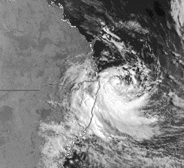
Figure 1. March 07, 2001, 22 GMT DMSP OLS visual image of the subtropical
system.
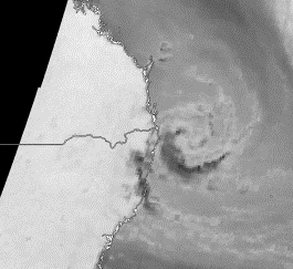
Figure 2. March 07, 2001, 22 GMT DMSP SSM/I (85H)
image of the subtropical system.
result, it became our interest to
determine whether (or not) the system did attain legitimate tropical
status. Evidence is presented to
suggest possible tropical transformation.
Data and Methodology
The general approach will be to demonstrate that the system
had (1) a warm core circulation, (2) Sea Surface Temperatures (SST’s) that were warm enough to support
tropical convection, (3) maximum winds near the center (nearly cyclostrophic
winds), and (4) favorable upper level winds.
DMSP imagery, including data from the SSM/I, was obtained
from the Satellite Data Handling System (SDHS) of AFWA. Visible, Infrared,
and SSM/I was retrieved and analyzed
for examining details of the subtropical vortex because of its ability to
determine scalar Ocean Surface Wind (OSW) speeds.
From
the SSM/I, the 85GHz (H) channel was used to determine the natures of the
internal thermal structure of the system. The 19, 37 and 22GHz channels are
used for determining surface wind speed.
The wind data from the NASA SeaWinds9+ sensor (onboard the
QuikSCAT satellite) are also used to demonstrate the nature of the surface circulation. The data displayed is a
visualization of the ‘Near-Real-Time’ (NRT) data being calculated by NOAA
NESDIS. The rain-flagged winds are depicted in a dark purple color in this
display (this preprint shows all wind barbs in white). The QuikSCAT wind barbs
were overlaid on GMS-5 imagery.
In addtion, this study makes use of the SST analysis from
the U.S. Naval Oceanographic Office near the coast of Australia. Also,
extensive use is made of the Numerical Weather Prediction (NWP) data from the
Navy’s NOGAPS model, as well as the NOAA NCEP AVN. Finally, conventional surface observations from Australia are
used to validate the wind field surrounding the storm.
Results and Discussion
(a)
Warm Core
The DMSP SSM/I data easily depicts the vortex (Fig.2). The feature is approximately 200 nm in diameter, which is consistent with the size of a tropical cyclone. Figure 3 shows the 85GHz V data from the same orbit, with a special enhancement to highlight the broad distribution of brightness temperatures across the system. The white pixels show brightness temperatures ranging from 270K to 275K. All other greyshades are colder than the white colored areas. The center of the circulation is shown near the end of the arrow. The area of darker grey shades (located from west to southwest through to the south) represent an area of significant convection. 85 GHz is spectrally quite close to the 89 GHz channel of the NOAA AMSU instrument, thus, we expect the 85 GHz to provide some insight into the

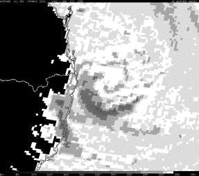
Figure 3. March 07, 2001, 22 GMT: DMSP SSM/I (85V)
enhanced image of the system.
surface thermal structure of the storm. While these brightness temperatures should
not be directly interpreted as ‘surface
temperature’, the gradient of 85 GHz brightness temperature should give us some
clue into the distribution of surface
moisture temperature and possibly temperature – so long as no convection is
evident overhead. The pattern in figure 3 -
near the center - suggests that
the storm could have a warm core.
Further
evidence of a possible warm core circulation is provided by the NCEP AVN 850
hPa heights and temperature analysis from 08 March 2001, 00 GMT, provided below
(The graphic comes from NOAA Air Resources Laboratory). The 850 analysis
shows a thermal ridge of 15-16oC over the center of the circulation. The overall pattern is - at best - one of a
hybrid system, with potential signs of tropical transformation.
![]()
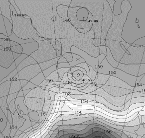
Figure 4. March 08, 2001, 00 GMT: NCEP AVN 850hPa
analysis (Graphic from NOAA ARL).
(b) SST pattern
These clues are not obvious
enough – by themselves - to declare that a tropical cyclone has formed, but
neither are they ideal extratropical nor subtropical signatures. Further
evidence is provided by the SST analysis from the Naval Oceanographic Office of
Bay St Louis Mississippi. Shown in figure 5, the SST pattern of 26oC
(outlined in a heavy Black on the figure) indicates that sufficiently warm
ocean water temperatures existed in the area around the systems’ track. This
would provide stronger support for the notion of tropical cyclogenesis, since
the near surface values of qe would
likely be higher. This notion is
supported by the higher brightness temperatures seen in the DMSP SSMI imagery
(see figure 3).
(c) Central Maximum
Winds
The surface winds of this system were well depicted by both the NASA QuikSCAT data (figure 6) and the SSMI OSW product (figure 7). Figure 6 shows the storm near landfall, with gales force winds near the center, as we would expect for a tropical cyclone. These winds were validated by several surface observations, the most notable of which came from Evan Heads (BSN 94598 - the black arrow in figure 6 gives the approximate location). The strongest winds were from 170 degrees at 54 knots with gusts to 75 knots at 08 March 2001, 0615Z.
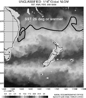 Figure 5.
March 08, 2001, 00 GMT: NCEP AVN 850hPa analysis (Graphic from NOAA ARL).
![]()
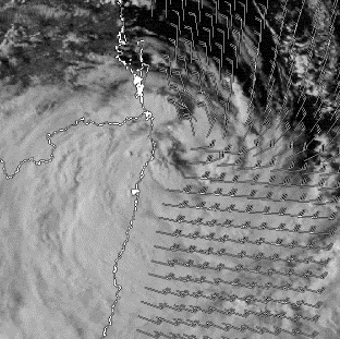
Figure 6. GMS-5
Visual image of the cyclone with QuikSCAT winds (08 March 2001, 06Z)
(d) Favorable Upper
Level Winds
Finally, the 250mb analysis from the NCEP AVN (figure 7) indicates that the system was – on 08 March 2001 – under a weak wind shear environment. The black arrow in figure 7 shows the approximate location of the surface circulation with respect to the winds aloft. There was a moderate subtropical jet located to the northeast of the storm. This feature likely contributed to further tropical cyclone formation by encouraging increased upper level outflow.

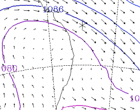
Figure 7. March 08, 2001, 00 GMT: NCEP AVN 250hPa
analysis (Graphic from NOAA ARL).
Conclusion:
Based
on the evidence presented above, there is sufficient evidence to suggest that
this subtropical cyclone did – in fact – transform into a tropicial cyclone.
During the time of the event, there was some confusion as to whether tropical cyclone warnings should have been
issued. It is suspected that the
subtropical origin of this storm may have caused problems indentifying and
classifying this system properly. We can’t track all
subtropical systems, but we can and should track those that exhibit the following
characteristics:
·
Located in the tropics/subtropics (south of
35 N / north of 30 S)
·
Develops deep convection near low level
circulation center
·
Low level qe maximum near center
- High
SST’s are a clue.
·
Wind Maximum near circulation center
·
Unusual Motion observed
- Most subtropical systems move east
-
Quasi-stationary
-
Retrograde (westward) motion observed
While no set of guidelines will ever suffice to handle
all special case storms, these will help identify many future transformation
events.
Acknowledgements:
The
author would like to thank Dr. Paul Chang of NOAA NESDIS for the use of the
NASA QuikSCAT lite data and for technical advice.
References
Morrison,
I., and S. Businger, 2000: Synoptic Structure and Evolution of a Kona Low,
Preprints, 24th Conference on Hurricanes and Tropical Meteorology,
American Meteorological Society, 45 Beacon St. Boston MA 02108, pp. 382-383.
Goodberlet,
M.A., C.T. Swift and J.C. Wilkerson, 1989: Remote sensing of ocean surface
winds with the Special Sensor Microwave/Imager. J. of Geophys. Res., 94,
14547-14555